GIS-DESIGNED WALL ART

Minimalist city maps, built from real geographic data.

Original poster art drawn in GIS from real streets, coastlines and parks — six color palettes, an ever-growing city collection, delivered as instant digital downloads.

Six palettes, one studio

Every city, styled six ways
Obsidian Line
Mono, dark
Cyan Pulse
Teal on navy
Navy Classic
Navy & white
Sandstone
Cream & terracotta
Ink
High-contrast B/W
Harbor Blue
Coastal port guide

From the collection

View all cities →
IstanbulObsidian Line
41.0082° N, 28.9784° E
From [PRICE] · instant download
59×84cm50×75cm50×70cm45×60cm40×50cm33×42cm
DubaiCyan Pulse
25.2048° N, 55.2708° E
From [PRICE] · instant download
59×84cm50×75cm50×70cm45×60cm40×50cm33×42cm
Los AngelesNavy Classic
34.0522° N, 118.2437° W
From [PRICE] · instant download
59×84cm50×75cm50×70cm45×60cm40×50cm33×42cm
New YorkInk
40.7128° N, 74.0060° W
From [PRICE] · instant download
59×84cm50×75cm50×70cm45×60cm40×50cm33×42cm

Landmark series

One landmark, one poster

A second, separate line: vintage travel-style posters built from historical large-format photography and, where the survey data exists, aerial LiDAR measurements — currently strongest for US landmarks; European pieces run on photography alone.
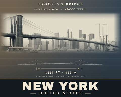
Brooklyn Bridge landmark poster
Brooklyn BridgeLIDAR-MEASURED
New York, United States
From [PRICE] · instant download
14×11in20×16in24×18in
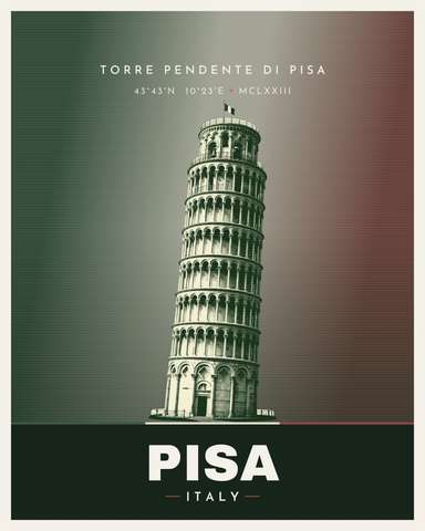
Torre di Pisa landmark poster
Torre di PisaPHOTO-ONLY
Pisa, Italy
From [PRICE] · instant download
11×14in16×20in18×24in
DON’T SEE YOUR CITY?

Request any city, in any of the six styles.

Name the city, the style and the size. The exact area the poster will cover is confirmed with you before it’s built, so there are no surprises.

Obsidian Line Cyan Pulse Navy Classic Sandstone Ink Harbor Blue
59×84cm 50×75cm 50×70cm 45×60cm 40×50cm 33×42cm

No stock templates. The geography is real — the composition isn’t.

Every poster starts as real GIS data — streets, coastlines, parks and rail lines — processed and hand-styled into a print-ready piece. Built by a working GIS analyst, not generated from a generic map template.

1. Real data
Streets, water and parks pulled from open geographic datasets for the exact city.
2. Hand-styled
Composed and styled in one of six original palettes, built for print, not screen.
3. Instant download
A high-resolution file lands in your inbox, ready for your own print shop.
OWN YOUR CITY

Every poster, every style, ready to print today.

High-resolution files for standard poster sizes, delivered instantly after checkout — no shipping, no waiting.

SHOP THE COLLECTION